Moreau Falls Hike (Goyave, Guadeloupe) - How to find them?
- Corentin Dutal

- Feb 24, 2025
- 3 min read
Updated: Apr 30, 2025
GPS track of the hike to the Moreau Falls (5 in total). The largest waterfall, 100m high, is made up of three levels. This makes it the third highest waterfall in Guadeloupe, after the First Carbet Falls (115m) and the Second Carbet Falls (110m)! Located on the Mangle Ravine, Les Chutes Moreau are made up of several waterfalls scattered in several places, more or less easy to find. The GPX track proposed here indicates them all.
The path to get to the start of the hike by car is long and steep. Then count 5h30 round trip to do all the Falls (8km round trip). The path is long, muddy and full of roots. You will cross the river 8 times, do not forget to check the weather and do not take any unnecessary risks. Also, access to the hike and to the foot of the falls has been closed by municipal decree , find out if it is still closed before undertaking this hike.
Save money by purchasing our Top 10 Guadeloupe Hikes GPX bundle — get all the best trails at a discounted price!
Photos of the Moreau Falls in Guadeloupe
How long ?
Allow approximately 5.5 hours round trip (8km)
Difficulty
Medium/Hard
The length of the hike and the terrain (mud, roots, river) make this hike not suitable for everyone.
What should be planned?
Good walking shoes A K-way
Lots of water
A mobile phone with GPX track (Mine shows all the Falls, not just the main one)
You must leave in the morning

Start of the hike
Moreau Falls in Goyave: Complete Guide to the Hike and Discovery of 5 Hidden Waterfalls
The Moreau Falls , located in Goyave in Guadeloupe, are a set of waterfalls nestled in the heart of the tropical rainforest. Among them, the most impressive reaches a height of 100 meters, making it the third highest waterfall on the island after the First and Second Carbet Falls.
Access and Departure of the Hike
To reach the starting point, take the Moreau forest road to the designated parking lot. The path is steep and can be difficult for some vehicles. It is recommended to check the condition of the road before venturing there.
The Route: Between River Crossings and Muddy Trails
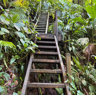
The hike, about 8 km round trip, takes an average of 5.5 hours. The trail crosses the Moreau River and the Mangle Ravine several times, requiring fording. The terrain is often muddy and strewn with roots, making progress sometimes slippery and difficult. Steeper sections are equipped with ropes and stairs to facilitate access. It is essential to wear suitable shoes and to exercise caution, especially in rainy weather when the water level can rise quickly.
I advise you to first do Chute 0, which you will find on the way to Chute Moreau. This Chute 0 is much more beautiful in real life than in photos. Then, head to the main Chutes Moreau. On the way back down, stop at Chute 2 and Chute 3, which are side by side. Finally, take a detour on the way back to admire Chute 4.
Points of Interest
In addition to the majestic waterfalls, the surrounding forest is home to a rich biodiversity. Chestnut trees, gum trees and tree ferns dominate the landscape, offering hikers a breathtaking natural spectacle. Swimming enthusiasts can enjoy the natural pools formed at the foot of the falls, offering a well-deserved refreshing break.
Practical Advice
Check weather conditions : Avoid rainy days due to flood risk.
Appropriate equipment : Hiking shoes with good grip, suitable clothing and a swimsuit to enjoy the pools.
Provisions : Bring plenty of water and energy snacks.
GPX track available with the 5 Falls : To make your route easier, a GPX track can be downloaded.
Before planning your visit, it is crucial to note that access to the hike and the foot of the falls has been closed by municipal decree. It is therefore essential to inquire about the opening of the site with local authorities or tourist offices to avoid any inconvenience.
Download the GPX Track of the Hike
For those who wish to explore the Moreau Falls independently, we offer a detailed GPX track of the hike, to be opened on an application such as maps.me
Save money by purchasing our Top 10 Guadeloupe Hikes GPX bundle — get all the best trails at a discounted price!
%20(942%20x%20204%20px).jpg)


Comments