%20(942%20x%20204%20px).jpg)
Crashed DC-3 Plane Hike on Soufrière (Saint-Claude, Guadeloupe) - How to find it?
- Corentin Dutal

- Feb 11, 2025
- 3 min read
Updated: Apr 30, 2025
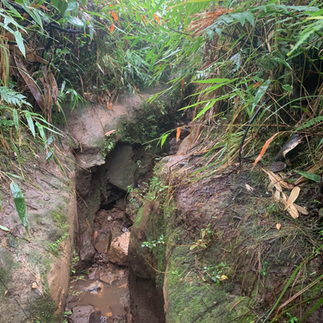
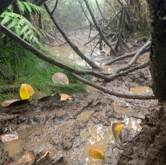
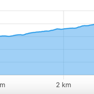
GPS track of the hike to go to the crashed DC-3 plane on the Soufrière in Guadeloupe. The hike is not official and must be done with caution, taking into account your level and the weather. The hike is long, about 10 km round trip for 5-6 hours of walking. Part of the path is off the trails and is very muddy (see photos). It is not uncommon to have mud up to your knees, or even up to your thighs. Start it imperatively early in the morning for more light. This plane is probably the best known of the three crashed planes and found on the territory of Guadeloupe (excluding maritime crashes).
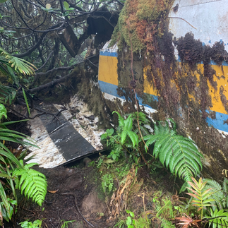
Photos of the DC-3 plane crashed on La Soufrière in Guadeloupe


How long ?
Allow 6 hours round trip
Difficulty
Difficult and potentially dangerous
The hike is long, off-trail, muddy and with elevation.
Notify a relative in advance who can contact emergency services if necessary.
Don't go there alone.
What should be expected?
Good walking shoes A K-way
Lots of water
What to eat
A cell phone
A survival blanket

Start of the hike
Hike to the DC-3 wreck on Soufriere
The wreck of the DC-3 lies on the heights of the Soufrière massif in Guadeloupe. This hike allows you to discover the remains of this aircraft of the Carib West Airways company, while traveling a varied and demanding route.
Access and departure of the hike
The start is from the Bains Jaunes car park , located at an altitude of around 950 m. From there, the route follows the Pas du Roy , a well-marked path that gradually climbs towards the Savane à Mulets, a former parking area that is now inaccessible by car. This first section is relatively easy and well-maintained.
After reaching the Savane à Mulets, the trail continues on the Chemin de la Dame , a more rugged passage where the terrain becomes rocky and exposed to ambient humidity. Continuing the climb, we reach the intersection leading to Carmichael , a key point offering a panoramic view of the surroundings.
The off-piste approach to the wreckage
Access to the wreck is not indicated by official markings. You have to take an off-piste path that plunges into dense and sometimes muddy vegetation. This passage requires good orientation and increased vigilance, because the progression can be slippery. After a final descent, you finally arrive at the site of the DC-3 wreck.
The story of the DC-3 crash
On October 9, 1971 , a Douglas DC-3 aircraft operated by Carib West Airways crashed into the side of the volcano while flying from Pointe-à-Pitre to Dominica. The accident occurred in adverse weather conditions, with poor visibility due to low clouds.
The aircraft was carrying passengers and cargo. Unfortunately, the crash left no survivors. Rescue operations took several days to locate the wreckage due to difficult terrain and changing weather conditions. Today, the remains of the aircraft, including fragments of the fuselage and engines, are still visible at the site.
Tips for hiking
Level : Difficult, due to off-piste passage and unpredictable weather.
Duration : Approximately 6 hours round trip.
Equipment : Hiking shoes, waterproof clothing, GPS or GPX track.
Weather conditions : Check before leaving, the area is often foggy and humid.
Conclusion
The hike to the DC-3 wreck offers an immersion in the history of aviation in Guadeloupe, while crossing one of the most emblematic massifs of the island. Access remains demanding and reserved for experienced hikers, but the site is a poignant testimony to the past.
Download the GPX Track of the Hike
For those who wish to find the crashed DC-3 plane on Soufrière independently, we offer a detailed GPX track of the hike, to be opened on an application such as maps.me


Comments